Archaeotechnology
Bir Umm Fawakhir: Insights into Ancient Egyptian Mining
Carol Meyer
Archaeological surveys at the site of Bir Umm Fawakhir in the central Eastern Desert of Egypt have clarified its role as a 5th-6th century gold-mining town. To date, 152 out of an estimated 216 buildings in the main settlement have been mapped in detail, eight outlying clusters of ruins have been identified, and four ancient mines have been inspected. In conjunction with Diodorus Siculus' first century B.C. account of Egyptian gold mining, the recent archaeological discoveries permit new insights into ancient Egyptian mining towns and techniques. Some evidence of activity at Bir Umm Fawakhir in earlier Roman, Ptolemaic, and pharaonic times has also been found.
Until recently, the Byzantine/Coptic rulers of Egypt were believed to be too weak to control the deserts and, thus, effectively abandoned them to nomadic tribesmen.1 However, new evidence from sites such as the fort at Abu Sha'ar, the port at Berenice, the settlement of Bir Umm Fawakhir, the imperial porphyry quarries at Mons Porphyrites, Wadi Nakheil, and other smaller sites indicates that this was not true. Admittedly, the textual evidence from the period contains little on the subject of deserts, mines, and quarries, but the texts do make it clear that the Byzantine emperors of the 5th and 6th centuries were deeply concerned about taxes, money, and gold supplies. Imperial expenses were staggering for armies, navies, wars, and ransoms as well as for improving the loyalty of dubious allies; the lavish construction of cathedrals, churches, and monasteries; and the court itself. Although many sources of gold have been suggested (confiscation from pagan temples; deposits in Turkey; or imports from East Africa, the Sudan, sub-Saharan Africa, or the Caucasus), Egypt has never been mentioned.2 This is a little surprising as Egypt was famous throughout antiquity as a gold source.
The Bir Umm Fawakhir site, surveyed by the Oriental Institute of the University of Chicago in 1992, 1993, and 1996, is the first entire ancient Egyptian gold-mining community to be studied archaeologically. Located in the central Eastern Desert of Egypt, Bir Umm Fawakhir was long believed to be a Roman caravan station serving traffic traveling from the Nile to Red Sea but was actually a 5th-6th century Byzantine/Coptic gold-mining town. The sprawling settlement is estimated to have housed slightly more than 1,000 people who worked the mines riddling the mountainsides and reduced and washed the ore. Although direct textual evidence is lacking, it seems probable that in light of the compelling need for gold, the imperial governors of the Thebaid (Upper Egypt) and their bureaucracies were concerned with the mines at Bir Umm Fawakhir, their product, and their support. Also, it is difficult to see who, apart from the government, could have recruited and routinely supplied so many workers in so remote a region.
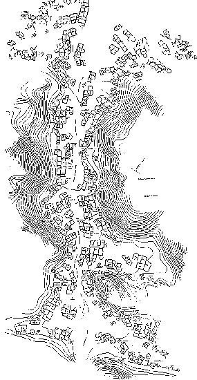 |
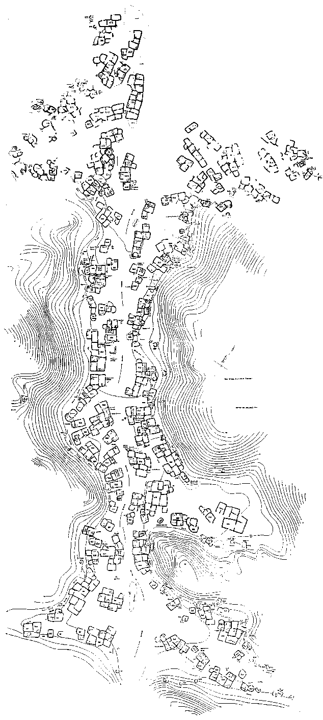
| Figure 1. A map of Bir Umm Fawakhir main settlement showing areas mapped in 1992, 1993, and 1996.
|
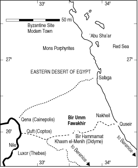
Bir Umm Fawakhir lies in the rugged Precambrian mountains of the central Eastern Desert and is almost exactly halfway between the Nile and the Red Sea. The site is approximately 65 km (two and a half to three days by camel) from Quft (ancient Coptos). This route, which is the shortest from the Nile to the Red Sea, has been in use for at least 5,000 years and follows a series of wadis (dry canyons) cutting through the mountains. The most famous ancient site enroute is the Wadi Hammamat, which was the source of a fine-grained dark graywacke that was highly prized in pharaonic times for statues, sarcophagi, and the like.
Bir Umm Fawakhir, about 5 km northeast, lies in a different geological zone. The Fawakhir granite is a stock intruded into the older Precambrian rocks. As no agriculture has ever succeeded in this hyperarid desert, the only resources are mineral, namely, gold, granite, and water. The granite was quarried to no great extent in the Roman period, but it also acts as an aquifer, carrying water in tiny cracks until it is stopped by the dense ultramafic rocks to the west.3 Wells have always been dug there. Most importantly, however, the quartz veins injected into the granite are auriferous, particularly towards the edge of the stock. (Many other minerals occur as well, including pyrite, chalcopyrite, and hematite, which stains the quartz reddish.)
Estimates of the gold yield vary widely.4,5 What is consistent among these analyses, however, is the conclusion that the yield at Bir Umm Fawakhir is very low compared to the older mines about 4 km southeast in the Wadi el-Sid. The latter were probably worked out well before the Coptic/Byzantine period. The combination of the paucity of rich ore sources as well as the urgent need for gold in the 5th and 6th centuries probably explains why the low-yield mines at Bir Umm Fawakhir were worked and why virtually nothing has happened at the site since.
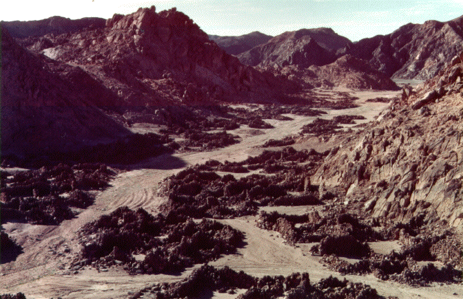
The main settlement at Bir Umm Fawakhir is not visible from the road, but after turning the spur of a hill, a visitor can walk the length of the Coptic/Byzantine town for about half a kilometer (Figure 1). The ruins lie in a long, narrow wadi, the steep sides of which enclose the town like a wall, while the sandy bottom serves as the main street (Figure 2).
Researchers have mapped, in detail, 152 out of an estimated 216 buildings so far. Individual houses are laid out on both sides of the street, and many are still a meter or more in height. Doors, stone benches, and wall niches for storage are also preserved in many cases. The basic pattern is a two- or three-room house, but several houses are often joined into larger agglomerated units. The largest building mapped so far is Building 106, which has 22 rooms.
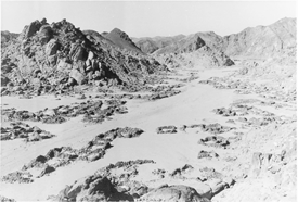 |
| Figure 2. A view of Bir Umm Fawakhir's main settlement. The plaza area is shown in the foreground surrounded by buildings 92, 100, 101, 102, 99, 97, and part of 93. Granite Quarry 2 lies at the foot of the hill on the left. The main street runs northwest toward the modern road and settlement. The Roman watch tower is on the mountain top at the far upper right. (Photograph by Henry Cowherd.)
|
Scattered around the houses are a number of one-room outbuildings: a smaller, rounded type and a larger, rectangular kind. Without excavation, it cannot be determined whether the outbuildings were used for kitchens, workshops, animals, storage, latrines, or something else.
Several cemetery areas have also been identified on the ridges around the town. The graves are simple cists built of granite slabs or natural clefts in the granite with cairns piled on top. All of the graves found so far are small and thoroughly looted, but the pottery scattered around them indicates that they are of the same period as the main settlement.
Apart from the sherds, which are thick on the ground and used as the primary dating evidence,2,3,6 surface finds are sparse. In particular, no written evidence has yet been recovered from the site aside from the dipinti, which are dockets painted in red on the shoulders of wine jars. Written in a cursive Greek hand and highly fragmentary, the dipinti have so far yielded little information beyond showing the presence of an imported luxury (i.e., wine) at a remote site.
With the potential exception of two possible community bake ovens, all of the buildings mapped so far appear to be domestic. Crosses and other Coptic symbols indicate that the population was Christian, but no church has been located. Likewise, no administrative buildings, storehouses, or workshops have been found, although there is some reason to believe they existed closer to the modern road, where the wadi wash is heaviest.
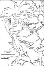 |
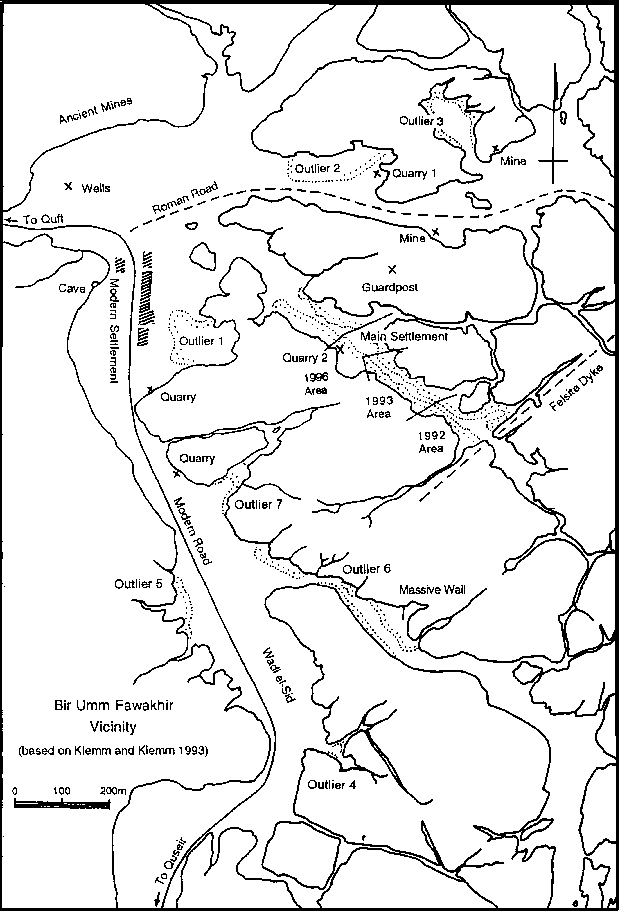
| Figure 3. A map of the Bir Umm Fawakhir vicinity showing the outlying areas and quarries.
|
Particularly striking is the lack of any formal defenses, which is surprising for a gold-producing site in a desert where security was often a concern. Only a couple of guardposts have been found on high ridges overlooking the site. The more prominent guardpost lacks any formal structures beyond a few rough walls for shade or windbreaks. It is marked by ancient graffiti scratched on granite boulders and commands a view of all three roads leading to the wells, many of the mines, and much of the settlement.
In addition to the detailed mapping of the main settlement, the researchers have also begun a walking survey of the immediate vicinity. Eight outlying clusters of ruins of the same date as the main settlement have been identified, and more may exist (Figure 3). The outlying sites range in size from a few huts to more than 60 buildings in one site (Outlier 6). Outlier 2, on the Roman road between the wells and granite quarry 1, is particularly well preserved. One house may still stand to its original height of about 2 m, and two houses have silos associated with them. The silos, built of cobbles and thick mud plaster, are of particular interest because such features have not been detected elsewhere on the site and because their association with individual houses does not suggest central control of grain rations.
| *Diodorus is frequently cited as the only ancient account of Egyptian gold mining. He states he tried to check his sources, but he relied on Agatharcides' account from the 2nd century B.C. It is not clear whether either writer ever saw a gold mine; however, Diodorus wrote approximately half a millennium before the Byzantine/Coptic operations at Bir Umm Fawakhir. If nothing else, the political and economic situation had changed. Diodorus' kings and queens of Egypt (the last of whom was Cleopatra) had long been replaced by distant emperors in Rome or Constantinople, and Egypt had been reduced to a province. |
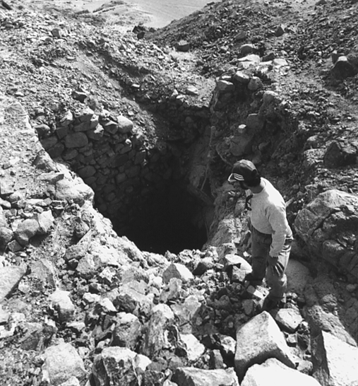
The ancient miners used two techniques: open-cast trenches following the quartz veins from the surface and shafts sunk horizontally or diagonally into the mountainsides. A number of the shafts had stone walls reinforcing the entrances or platforms at the edge, presumably to aid in raising and lowering men, boys, baskets, tools, and ore (Figure 4). In January 1996, the researchers inspected four of the mine shafts in order to determine the mining techniques used and to check the evidence from Bir Umm Fawakhir against the 1st century B.C. account of Diodorus Siculus.*
The first stage of mining that Diodorus describes is fire-setting, which is used to shatter the rock.
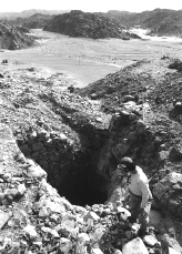 |
| Figure 4. A mine entrance with revetment. The main settlement lies in the long narrow wadi in the background. (Photograph by Henry Cowherd.)
|
The largest mine at Bir Umm Fawakhir inspected in 1996 runs about 100 meters horizontally into the mountain and is roughly two meters high. It has two short side galleries, an air shaft, and oblong holes pounded in the rock at the working faces. It shows no signs of fire-setting; there is neither charcoal nor ash, and none of the splintered-out niches characteristic of fire-setting. The granite is jointed, fissured, and rotten in places. This is especially true of the third and fourth mines inspected. The workings are primarily an open-cast trench running diagonally up a granite hill. In two places, however, they dive underground to follow the quartz veinlets. Here, the granite crumbles underfoot. Thus, there seems to have been no need for fire-setting; the quartz is tough, but the surrounding rock can be splintered away.
Diodorus also discusses how the stone is quarried.
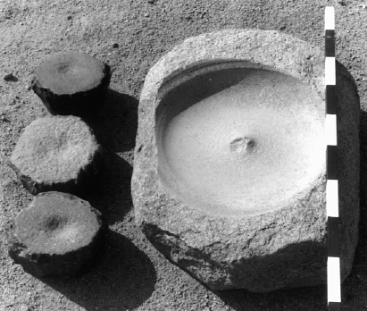
Iron tools, or metal of any sort, have not yet been found at Bir Umm Fawakhir. However, metal and wood are so precious in the desert that they would have been the first things removed. Mortars, in the sense of deep basins for pounding, are also not common at Bir Umm Fawakhir. Those that have been recovered are limestone, which is unsuitable for crushing quartz. On the other hand, hundreds of crushing stones have been found on the site. They are made of rough blocks of basalt, granite, or porphyritic granite with smooth upper surfaces that measure about 20 cm x 20 cm square, with a depression pecked in the middle (Figure 5). Almost all of the crushing stones were found in secondary context or loose on the surface, but one is still in situ at the mouth of the fourth mine inspected, with fist-sized and smaller chunks of quartz scattered around it. It seems then, that the ore, mined in virtual darkness, was immediately reduced at the mouth of the mine, and the pieces worth the considerable effort of further reduction were picked out.
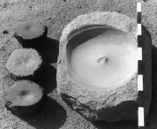 |
| Figure 5. Three dimpled crushing stones and the lower stone from a rotary mill. (Photograph by Henry Cowherd.)
|
Diodorus continues with the next stage of ore working.
The evidence compiled from the Bir Umm Fawakhir survey supports Diodorus' account. Both the upper and lower stones of numerous rotary querns or millstones have been found on site (Figure 5). Rotary mills are considered to have been a late Ptolemaic or Roman introduction; the earlier millstones were flat or concave.8,9 Not yet explained, however, are the saddle querns, which are grinding stones of granite or porphyritic granite that measure about 80 cm long and have a shallow dished-out depression. These were presumably worked with oblong upper handstones. It is unknown, however, whether the grinding stones were used at an intermediate stage of grinding (e.g., coarse versus fine), used for something else (e.g., wheat flour), or were earlier in date.
Diodorus describes gold-washing and refining.
| EARLIER ACTIVITY |
| Exploitation of the Eastern Desert extends far back into prehistory, but at Bir Umm Fawakhir, good evidence goes back only to the late New Kingdom period (ca. 1307-1070 B.C.). Middle Kingdom, Old Kingdom, and Predynastic (roughly 3200-ca. 1783 B.C.) inscriptions are present in the Wadi Hammamat, but not at Bir Umm Fawakhir or in the Wadi el-Sid.
Roman activity is attested, though it is less extensive than when the entire site of Bir Umm Fawakhir was considered 1st-2nd century A.D. The small granite quarries were probably Roman undertakings, although possibly only exploratory. There is a small amount of Roman pottery in Quarry 2 with quarrying marks identical to those at a known major granite quarry at Mons Claudianus. A couple of partly quarried blocks have been incorporated in 5th-6th century houses, and the Romans had an unexcelled passion for handsome and exotic stones. The Roman period ostraca (letters and messages written on potsherds) reported as coming from Bir Umm Fawakhir pertain to military activity10 and probably came from the vicinity of the modern mines in the Wadi el-Sid.
The modern mines, operated in the 1940s and 1950s, were probably the focus of most of the ancient efforts as well. Tailings there yielded a handful of sherds of Roman, possibly Ptolemaic (334-64 B.C.), and Late Period (26th Dynasty, 664-535 B.C.) dates.
The 1996 survey located the remains of late New Kingdom activity near the Wadi el-Sid mines. The Turin Papyrus, dateable to the reign of Ramses IV of the 20th Dynasty (ca. 1163-1156 B.C.), can reasonably be read as a map to the stone quarries in the Wadi Hammamat. The papyrus also shows a well with "a Mountain of Gold" and a "Mountain of Silver" just beyond.11
Thus, while the map indicates that pharaonic mines ought to exist in the vicinity of Bir Umm Fawakhir, the survey has only recently been able to document them. Some very large (ca. 8 m square) and heavy slabs with shallow depressions on the top, unlike the smaller and deeper Bir Umm Fawakhir grinding stones, may represent pharaonic or Ptolemaic ore reduction activities, but all stones found so far have been pushed out of any sort of context by modern road building.
|
The accounts of 19th century travelers do mention gold-washing tables at Bir Umm Fawakhir, but they have probably been destroyed by modern mining activity. It is unlikely that final refining was carried out on site. It seems more reasonable that the washed gold dust was then transported to the valley, where fuel was more abundant.
Field survey and analysis of the information gathered from Bir Umm Fawakhir is still in progress, but it is already apparent that the site can offer a great deal of information about ancient mining. First, it is an opportunity to study an entire mining community without excavation. Second, it is a remarkably complete community, even without such features as central administrative buildings or churches. Not only houses and outbuildings survive, but also streets, paths, roads, cemeteries, wells, guardposts, and mines and quarries. It is the first time an ancient Egyptian gold-mining site has been archaeologically studied and is one of the few documented gold sources within the Byzantine Empire.
Thanks are due to William Sumner of the Oriental Institute; Peter Dorman of Chicago House in Luxor, Egypt, American Research Center in Egypt, Cairo; and especially Amira Khattab; Abdel Aziz of the Egyptian Geological Survey and Mining Authority; private patrons; and the staff: Steven Cole, Henry Cowherd, Lisa Heidorn, Alexandra O'Brien, Mohamed Badr el-Din Omar, and Terry Wilfong.
1. J. Maspero, Organisation Militaire de l'Égypte Byzantine (Paris: H. Champion, 1912).
2. C. Meyer et al, A Byzantine Gold-Mining Town: The Bir Umm Fawakhir Survey Project, Oriental Institute Communications series (Chicago, IL: Oriental Institute), in press.
3. C. Meyer, "Gold, Granite, and Water: The Bir Umm Fawakhir Survey Project 1992," Annual of the American Schools of Oriental Research, 52 (1995), pp. 37-92.
4. T. Barron and W.F. Hume, Topography and Geography of the Eastern Desert of Egypt (Cairo, Egypt: National Printing Department, 1902), p. 261.
5. A Kochin, report to the Egyptian Geological Survey and Mining Authority on Eastern Desert gold occurrences, 1962.
6. C. Meyer, "A Byzantine Gold-Mining Town in the Eastern Desert of Egypt: Bir Umm Fawakhir, 1992-1993," J. of Roman Archaeology, 8 (1995), pp. 192-224.
7. Diodorus of Sicily, translated by C.H. Oldfather (Cambridge, MA: Harvard U. Press, 1967).
8. R. Klemm and D. Klemm, "Pharaonischer Goldbergbau im Wadi Sid und der Turiner Minenpapyrus," Akten des 4 Int. Ägyptologen-Kongresses München 1985 (Hamburg, Germany: International Congress of Egyptologists, 1988), pp. 73-87.
9. R. Klemm and D. Klemm, "The Development of Gold Ore Milling Technique from Predynastic to Arabic Time in Egypt," (Paper presented at British Museum Conference, 14-16 November, 1991).
10. O. Guéraud, "Ostraca Grecs et Latins de l'Wâdi Fawâkhir," Bulletin de l'Institut Français d'Archéologie Orientale (Cairo, Egypt: Imprimerie de l'Institut Français d'Archéologie Orientale, 1942).
11. J.A. Harrell and V.M. Brown, "The World's Oldest Surviving Geological Map: The 1150 B.C. Turin Papyrus from Egypt," J. of Geology, 100 (1992), pp. 3-18.
ABOUT THE AUTHOR
Carol Meyer is currently a research associate at the Oriental Institute at the University of Chicago.
For more information, contact C. Meyer, 1155 E. 58th Street, Oriental Institute, Chicago, Illinois 60637; fax (312) 595-1821 or (312) 702-9853; e-mail: cmeyer@midway.uchicago.edu.
Copyright held by The Minerals, Metals & Materials Society, 1997
Direct questions about this or any other JOM page to jom@tms.org.